Yesterday’s Urban Hike took Spoon and me along a path I walk almost every week. I do some some weekly garden maintenance over in the Cole Valley neighborhood of San Francisco. It’s a mostly uphill journey to get there, so I take the 33 Stanyan bus to the top of the hill at Clayton and Twin Peaks Blvd, and walk from there. Coming home, it’s a much easier walk than it is to get there. 🙂

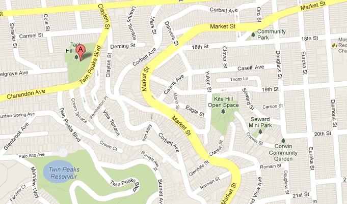
This map of Tank Hill shows its location and relative position to other parks I’ve covered as Urban Hikes.
After walking home from the job yesterday I decided to grab the dog and walk back, and highlight the fantastic plants and paths and views I get to see every week. My previous Urban Hikes have focused on many of the hilltop parks that I pass on this walk. (Click the links to explore those individual posts.) This is the exact reverse of my walk home from the garden gig.

Spoon posing in Kite Hill Park as we ascend. Tank Hill is on the other side of the valley, right above her head.
From home I climbed up and through Seward Mini Park on my way to Kite Hill. I sneaked out the back of Kite Hill via a path that leads to Stanton Street. Ringing the rim of Eureka Valley, I crossed Market and headed up Clayton, where Tank Hill looms overhead. Just above the intersection of Clayton and Corbett is the base of a staircase called Pemberton Place. I love staircase streets! Can you imagine, though, parking at the bottom of a hill and climbing a hundred steps just to get to your front door? The views make the inconvenience worthwhile in my book!
I just switched to this cool new gallery format to try it out. Mouse over a pic to see captions, or, when you click on any you can scroll through them all as a slideshow by clicks or by using your keyboard arrows… Fun stuff!

A fun Christmas tree rendition, against a blue house on Stanton.

The eastward view from Market St at Stanton, across Kite Hill.

Looking up at Tank Hill from Market St.

I’ve seen handle-less faucets before, but never have I seen a screw-in faucet protecter. Must be super-precious water!

Some lovely aloe flowers at Clayton and Corbett.

A truly bizarre little corner street garden at Clayton and Corbett. Lovely from afar, but…

…on closer look you can see the whole thing is cemented and painted brown to mimic dirt, with openings only large enough for the plants. Talk about weed phobia!

The base of Pemberton Place, at Clayton.

The first block of Pemberton.

Cute little entrances onto Pemberton.

A fascinating little rose garden along Pemberton. Every rose is labelled and dated with its historic cultivation date.

Spoon poses at a circular landing halfway up the first block.

The circular landing has a people-and-doggy drinking fountain for the weary climber.

A bench also provides a resting place on the landing, under an old monolith of a foundation remnant.
From the top of the Pemberton steps I turned onto Crown Terrace. The steepness of the hill is such that the uphill homes are Crown Terrace addresses, but the ones on the downhill side of the street with garages have Graystone Terrace addresses, since their front doors are actually on the street below Crown Terrace. Crown Terrace ends at Twin Peaks Blvd, directly across from the base of some wooden steps into Tank Hill Park.

The second block of Pemberton, as we cross Villa Terrace.

Looking south along Villa Terrace towards the open space at Twin Peaks.

Stunning silver tree (Leucadendron argenteum) at the Villa St crossing. The pincusion (Leucospermum) underneath it has, um, “assisted” me in Ikebana classes before.

I love the ruins-like feel of this facade, and the pot atop the buttress.

Pemberton continues as another block above Graystone Terrace.

A house on Graystone with a lovely terraced succulent garden in front.

The stair post on Graystone, under an old tea tree (Leptospermum).

This is my favorite block of Pemberton. The older, mossy steps are uneven and require slower walking and contemplation as you climb.

Fun little garden details along the way, like the metal bird on the gatepost under a metal lamp post.

Bright greens along the shady stairs.

Amusing repositioning at 69 Crown Terrace.

Walled garden on Crown Terrace, with a Graystone Terrace garage.

Nice shot of blue on Crown Terrace.

The staircase into Tank Hill Park, as seen from Crown Terrace where it meets Twin Peaks Blvd.
The views from Tank Hill are amazing! You can see all around from there. Twin Peaks is to the south, across Cole Valley is Sutro Forest to the west, across Golden Gate Park all the way to Marin County in the north. You can see Buena Vista Park, Corona Heights Park, Kite Hill Open Space, Bernal Heights Park, and the whole bay. Really a lovely park for the worthwhile views.
Tank Hill Park is a bit of a “natural-ish” open space. The hill is so-named because it was once the site of (wait for it… wait for it…) a TANK! A big water tank, for the sake of gravity-feeding water to the homes below. That’s now accomplished via the reservoir up at Twin Peaks, but a big cement circle and remnants of pipes hint at its historic past. It’s not a picnic table kinda park. No matter how you get into it, you have to climb. The plantings are pretty wild, and it’s preferred that you stay on the bordered paths to avoid trampling habitat restoration. But the views really make it what it is. I’ve actually encountered a coyote in this park once!

Lush greens in the rainy season greet you at the top of the steps in the Radiolarian Chert promontory that is Tank Hill Park.

Northwest view across the cement slab that once held the tank for which the park was named.

Another remnant from the park’s past as a water tank.

Old iron pipes and valves can be tripping hazards if you stray from the outlined paths, but are archaeologically fascinating.

From the top you can look to the north and see Buena Vista park on the left and Corona Heights just below it to the right.

To the southeast is the green patch of Kite Hill. Bernal Heights is the knob above that and slightly to the right.

West of Tank Hill is Sutro Forest, which will be a future Urban Hike post, no doubt. The garden I tend is as the far end of that street visible just left of center.

Marin County across the Golden Gate Strait.

Spoon posing for a northern vista shot.

Steep steep downhill drop from the summit, on the northern side.

Golden Gate Park is the band of green, and the ocean is visible above that.

Another angle of the concrete circle where the tank once stood.

Detail of the concrete slab’s texture.

We wound our way back down the way we came, but explored Corbett a bit. Fun little wooden carving we passed.

This sort of super-manicured formality isn’t all that common in this part of the city.

I liked the stacked cubes of the architecture of these apartment buildings.

Nice botanical tiling on Corbett at Romain.
Thanks for coming along on another Urban Hike! Until next time…


Pingback: Garden Installation: Mount Olympus Rental | boZannical Gardens